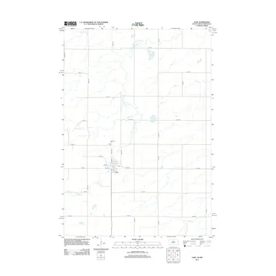
2012 Map of Gary
USGS Topo · Published 2012About this map
Gary sits at the heart of this South Dakota-Minnesota borderland survey, positioned where the W Br Lac qui Parle River winds through the prairie. The town's grid is centered around Main Ave, 1st Ave, and Herrick St, reflecting a classic Midwestern settlement pattern. Outside the immediate town limits, the landscape is defined by a dense network of sectional roads and the serpentine paths of several waterways, including Cobb Cr and Monighan Cr. For those researching local heritage, the map identifies Grandview Cem and Calvary Cem north of the town center. The area's hydrology is complex, with Florida Cr and Crow Cr draining the agricultural expanses that dominate the landscape on both sides of the state line.
Find a feature on this map
33 named features on this map. Tap any name to fly to it.
Don’t see what you’re looking for? This feature index may not catch every label — zoom into the map to look around manually.
Map Details
Editions of this 2012 Gary Map
This is the sole edition of this map. No revisions or reprints were ever made.
Other maps of this area

1953 · Watertown
USGS Topo · 1:250,000

1958 · Watertown
USGS Topo · 1:250,000

1967 · Canby
USGS Topo · 1:24,000

1967 · Gary
USGS Topo · 1:24,000

1967 · Canby NW
USGS Topo · 1:24,000

1967 · Gary SE
USGS Topo · 1:24,000

1967 · Gary NW
USGS Topo · 1:24,000
1967 · Mount Wickham
USGS Topo · 1:24,000

1970 · Brandt
USGS Topo · 1:24,000
1973 · Lake Francis
USGS Topo · 1:24,000