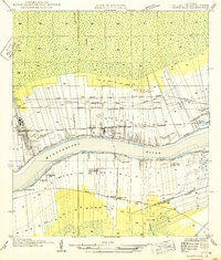
1949 Map of Garyville
USGS Topo · Published 1949About this map
Sugar production and river transportation anchor this mid-century survey of the Mississippi River corridor. The landscape is defined by the historic long-lot land divisions extending away from the river banks, a pattern deeply ingrained in Louisiana's plantation history. Major industrial landmarks include the Columbia Sugar Mill and the Gold Mine Sugar Mill, which reflect the region's agricultural economy. The river itself serves as the central artery, flanked by the Texas and Pacific and Illinois Central railroads, which facilitated the movement of goods and people between riverside settlements.
Find a feature on this map
31 named features on this map. Tap any name to fly to it.
Don’t see what you’re looking for? This feature index may not catch every label — zoom into the map to look around manually.
Map Details
Editions of this 1949 Garyville Map
This is the sole edition of this map. No revisions or reprints were ever made.
Other maps of this area

1891 · Hahnville
USGS Topo · 1:62,500

1892 · Lac Des Allemands
USGS Topo · 1:62,500

1892 · Mount Airy
USGS Topo · 1:62,500

1892 · Bonnet Carre
USGS Topo · 1:62,500

1932 · Lac Des Allemands NW
USGS Topo · 1:31,680

1932 · Hahnville NW
USGS Topo · 1:31,680

1932 · Lac Des Allemands NE
USGS Topo · 1:31,680

1935 · Laplace
USGS Topo · 1:31,680

1936 · Hahnville
USGS Topo · 1:31,680

1936 · Ruddock
USGS Topo · 1:31,680