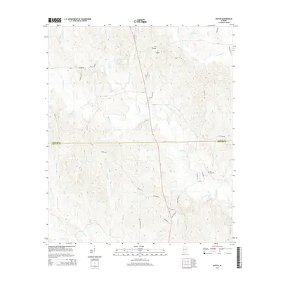
2014 Map of Gaston
USGS Topo · Published 2014About this map
Gaston and Derby anchor this West Alabama landscape, where the rural topography is defined by the winding course of Kinterbish Creek and its many tributaries. The terrain transitions across the Sumter and ChoctAW county line, revealing a network of family and community landmarks such as Campbell Cem and Ward Chapel Cem. The transportation corridors, including Al-17 and Polecat Creek Rd, follow the natural ridgelines between drainage basins like Cotohaga Cr and Brockway Cr. Local history is embedded in the road names, from Christopher Chapel Rd to Cooper Mission Rd, which point to the centers of social life in this wooded region. The northern section is marked by Allison Derby Lake, a notable water feature in a landscape dominated by small branches and creeks that have historically shaped the settlement patterns of this borderland area.
Find a feature on this map
45 named features on this map. Tap any name to fly to it.
Don’t see what you’re looking for? This feature index may not catch every label — zoom into the map to look around manually.
Map Details
Editions of this 2014 Gaston Map
This is the sole edition of this map. No revisions or reprints were ever made.
Other maps of this area

1953 · Meridian
USGS Topo · 1:250,000

1957 · Meridian
USGS Topo · 1:250,000

1965 · Meridian
USGS Topo · 1:250,000

1971 · Whitfield
USGS Topo · 1:24,000

1971 · Coatopa
USGS Topo · 1:24,000

1971 · Gaston
USGS Topo · 1:24,000

1971 · Bellamy
USGS Topo · 1:24,000

1974 · Ward
USGS Topo · 1:24,000

1974 · Lisman
USGS Topo · 1:24,000
1974 · York
USGS Topo · 1:24,000