
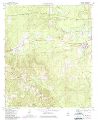
1971 Map of Bellamy
USGS Topo · Published 1974About this map
The logging and rail landscape of Sumter County is well-defined here, centered on the company town of Bellamy. The community is dominated by the industrial infrastructure of the Sumter and Choctaw Railroad and localized amenities like the Lamkin Sch. To the west, the rural character is punctuated by numerous small house of worship including Morning Star Ch, Chestnut Grove Ch, and Elizabeth Ch, reflecting the close-knit social fabric of the era. The Sucarnoochee River and its tributaries, including Cotohaga Creek, carve through the terrain, while the Southern line passes through Curl Station and Lilita in the north. This survey documents the intersection of heavy timber industry transport and traditional rural settlements like Intercourse before modern expansion.
Find a feature on this map
32 named features on this map. Tap any name to fly to it.
Don’t see what you’re looking for? This feature index may not catch every label — zoom into the map to look around manually.
Map Details
Editions of this 1971 Bellamy Map
2 editions found
Other maps of this area

1929 · Epes
USGS Topo · 1:48,000

1932 · Epes
USGS Topo · 1:62,500

1953 · Meridian
USGS Topo · 1:250,000

1957 · Meridian
USGS Topo · 1:250,000

1965 · Meridian
USGS Topo · 1:250,000

1971 · Whitfield
USGS Topo · 1:24,000

1971 · Coatopa
USGS Topo · 1:24,000

1971 · Gaston
USGS Topo · 1:24,000

1974 · Boyd
USGS Topo · 1:24,000

1974 · Ward
USGS Topo · 1:24,000