
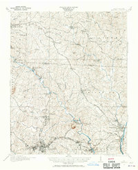
1914 Map of Gastonia
USGS Topo · Published 1914About this map
Gastonia and Lincolnton anchor this detailed 1914 survey of the Piedmont region, showing the industrial and social landscape of Gaston and Lincoln counties before the mid-century expansion. The map highlights the early 20th-century textile economy with landmarks like Loray Mills and the McAdenville junction. A dense network of railroads, including the Seaboard Air Line and the Piedmont and Northern, crisscrosses the terrain, connecting small mill towns and rural centers like Dallas and Mount Holly.
Find a feature on this map
94 named features on this map. Tap any name to fly to it.
Don’t see what you’re looking for? This feature index may not catch every label — zoom into the map to look around manually.
Map Details
Editions of this 1914 Gastonia Map
2 editions found
Other maps of this area

1893 · Statesville
USGS Topo · 1:125,000

1895 · Hickory
USGS Topo · 1:125,000

1905 · Charlotte
USGS Topo · 1:48,000

1906 · Kings Mountain
USGS Topo · 1:62,500

1907 · Charlotte
USGS Topo · 1:62,500

1908 · Kings Mountain
USGS Topo · 1:62,500

1909 · Lincolnton
USGS Topo · 1:62,500

1911 · Lincolnton
USGS Topo · 1:62,500

1916 · Gastonia
USGS Topo · 1:62,500

1941 · Charlotte
USGS Topo · 1:125,000