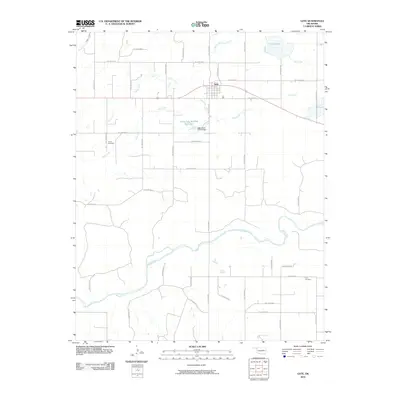
2010 Map of Gate
USGS Topo · Published 2010About this map
The Beaver River winds through the southern portion of this landscape, anchoring a network of drainage patterns and ranch roads in Beaver County. The small settlement of Gate sits near the intersection of major routes in the northern reaches, positioned between the waters of Gate Lake and the Hog Creek drainage. This 2010 survey illustrates the persistence of rural landmarks in the Oklahoma Panhandle, where the terrain is marked by named hollows and intermittent watercourses. Family history is anchored at sites like Zelma Cemetery in the west and Cline Cemetery to the southeast, while modern infrastructure is represented by the Oknoname 007004 Reservoir and its associated Oknoname 007004 Dam. The map's grid-like road system, including Hollow E0110 and Hollow N1660, provides a framework for understanding the scattered settlement and agricultural layout of this plains region.
Find a feature on this map
38 named features on this map. Tap any name to fly to it.
Don’t see what you’re looking for? This feature index may not catch every label — zoom into the map to look around manually.
Map Details
Editions of this 2010 Gate Map
This is the sole edition of this map. No revisions or reprints were ever made.
Other maps of this area

1954 · Perryton
USGS Topo · 1:250,000

1955 · Woodward
USGS Topo · 1:250,000

1958 · Perryton
USGS Topo · 1:250,000

1958 · Woodward
USGS Topo · 1:250,000

1970 · Knowles
USGS Topo · 1:24,000

1970 · Gate
USGS Topo · 1:24,000
1970 · Gate NE
USGS Topo · 1:24,000

1970 · Gate NW
USGS Topo · 1:24,000
1970 · Rosston NW
USGS Topo · 1:24,000

1971 · Rosston
USGS Topo · 1:24,000