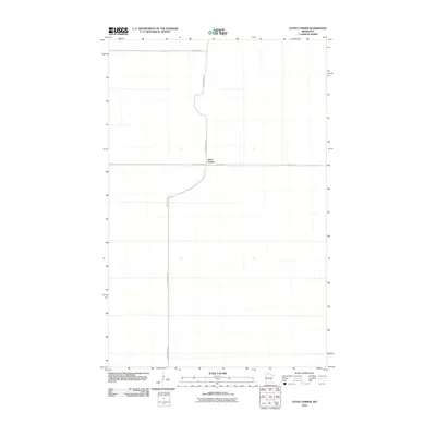
2010 Map of Gates Corner
USGS Topo · Published 2010About this map
Gates Corner serves as the central junction of this northern Minnesota landscape, where the local road network reflects the grid-based organization of Beltrami County. This 2010 survey illustrates a sparsely developed region primarily defined by its arterial routes. Major thoroughfares include Dicks Parkway Rd, which cuts north-to-south through the terrain, and Moose River Rd, which intersects at the primary settlement point. The presence of Gladens Trl and Morehouse Rd further delineates the land into large, uniform parcels, suggesting an area dedicated to forestry or agriculture. The map provides a clear look at the infrastructure as it existed at the start of the decade, capturing the precise locations of named trails and county roads in this quiet section of the state.
Find a feature on this map
5 named features on this map. Tap any name to fly to it.
Don’t see what you’re looking for? This feature index may not catch every label — zoom into the map to look around manually.
Map Details
Editions of this 2010 Gates Corner Map
This is the sole edition of this map. No revisions or reprints were ever made.
Other maps of this area

1918 · Winterroad
USGS Topo · 1:62,500

1918 · F
USGS Topo · 1:62,500

1918 · Malcolm
USGS Topo · 1:62,500

1954 · Roseau
USGS Topo · 1:250,000

1957 · Roseau
USGS Topo · 1:250,000

1958 · Roseau
USGS Topo · 1:250,000

1968 · Mulligan Lake SW
USGS Topo · 1:24,000
1968 · Mulligan Lake
USGS Topo · 1:24,000
1969 · Winter Road Lake SW
USGS Topo · 1:24,000

1973 · Gates Corner
USGS Topo · 1:24,000