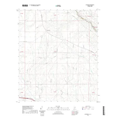
2020 Map of Gateswood
USGS Topo · Published 2020About this map
Gateswood serves as a central point in this rural landscape of eastern Baldwin County, situated where the Perdido River forms the natural boundary between Alabama and Florida. The terrain is defined by a dense network of tributaries including Hollinger Creek, Beetree Cr, and Bellefontaine Cr, which eventually feed into the Styx River at the southern edge of the survey. This 2020 edition provides a look at the modern road network, which still follows historic alignments like the Old Pensacola Rd and Waters Ferry Rd. For those researching local history, Pittman Cem is a notable landmark, while recreation is represented by the Perdido Canoe Trail - Section 1 (Water). The map illustrates the persistent rural character of the region, marked by named family routes such as Arley Minchew Rd and Peter Morris Rd.
Find a feature on this map
61 named features on this map. Tap any name to fly to it.
Don’t see what you’re looking for? This feature index may not catch every label — zoom into the map to look around manually.
Map Details
Editions of this 2020 Gateswood Map
This is the sole edition of this map. No revisions or reprints were ever made.
Other maps of this area

1920 · Robertsdale
USGS Topo · 1:62,500

1921 · Muscogee
USGS Topo · 1:62,500

1941 · Muscogee
USGS Topo · 1:62,500

1941 · Robertsdale
USGS Topo · 1:62,500

1941 · Century
USGS Topo · 1:62,500

1942 · Dyas
USGS Topo · 1:62,500

1943 · Robertsdale
USGS Topo · 1:62,500

1943 · Muscogee
USGS Topo · 1:62,500

1943 · Century
USGS Topo · 1:62,500
1944 · Muscogee
USGS Topo · 1:25,000