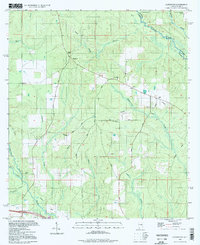
1994 Map of Gateswood
USGS Topo · Published 1998About this map
Gateswood serves as a central point in this part of Baldwin County, where the landscape is defined by the winding paths of the Perdido River and the Styx River. The map captures an era of resource extraction and local utility, evidenced by several Claypit locations and an Oil Well situated near Allen Road. Infrastructure such as the Lookout Tower and a Meter Sta along the Pipelines suggests a managed timber or utility landscape during the mid-to-late 20th century.
Find a feature on this map
33 named features on this map. Tap any name to fly to it.
Don’t see what you’re looking for? This feature index may not catch every label — zoom into the map to look around manually.
Map Details
Editions of this 1994 Gateswood Map
This is the sole edition of this map. No revisions or reprints were ever made.
Other maps of this area

1920 · Robertsdale
USGS Topo · 1:62,500

1921 · Muscogee
USGS Topo · 1:62,500

1941 · Muscogee
USGS Topo · 1:62,500

1941 · Robertsdale
USGS Topo · 1:62,500

1941 · Century
USGS Topo · 1:62,500

1942 · Dyas
USGS Topo · 1:62,500

1943 · Robertsdale
USGS Topo · 1:62,500

1943 · Muscogee
USGS Topo · 1:62,500

1943 · Century
USGS Topo · 1:62,500
1944 · Muscogee
USGS Topo · 1:25,000