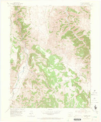
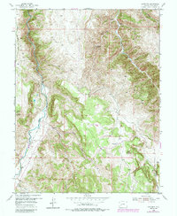
1954 Map of Gateview
USGS Topo · Published 1965About this map
Gateview sits at the convergence of rugged canyons and high peaks in Gunnison County, where the Lake Fork meets the Gunnison River. This mid-century survey documents a landscape defined by its extractive history and remote mountain transit. Remnants of the industrial past are visible in the Old Railroad Grade winding along the riverbanks, once a vital link through these narrow corridors. Higher in the mountains, the map identifies several mining sites, including the Dubois Mine (Inactive) and other unnamed workings that were no longer in operation by the mid-1950s.
Find a feature on this map
19 named features on this map. Tap any name to fly to it.
Don’t see what you’re looking for? This feature index may not catch every label — zoom into the map to look around manually.
Map Details
Editions of this 1954 Gateview Map
6 editions found
Other maps of this area

1903 · Lake City
USGS Topo · 1:62,500

1905 · Lake City
USGS Topo · 1:62,500

1908 · Uncompahgre
USGS Topo · 1:125,000

1911 · Uncompahgre
USGS Topo · 1:125,000

1954 · Iola
USGS Topo · 1:24,000

1954 · Cebolla
USGS Topo · 1:24,000

1954 · Sapinero
USGS Topo · 1:24,000

1954 · Gateview
USGS Topo · 1:24,000

1956 · Montrose
USGS Topo · 1:250,000

1959 · Montrose
USGS Topo · 1:250,000