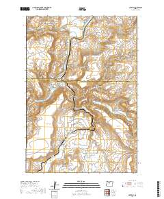
2020 Map of Gateway
USGS Topo · Published 2020About this map
Gateway serves as the central settlement in this high-desert landscape where the Wasco Co and Jefferson Co line crosses the Deschutes River. The terrain is defined by dramatic elevation shifts, moving from the river banks up through Frog Springs Canyon and Gate Spring Canyon to the broad, elevated surfaces of Agency Plains and Seattle Flat. The Warm Springs River enters the Deschutes at the northwestern edge of the map, illustrating the importance of these watercourses in an otherwise arid environment.
Find a feature on this map
41 named features on this map. Tap any name to fly to it.
Don’t see what you’re looking for? This feature index may not catch every label — zoom into the map to look around manually.
Map Details
Editions of this 2020 Gateway Map
This is the sole edition of this map. No revisions or reprints were ever made.
Other maps of this area

1928 · Madras
USGS Topo · 1:125,000

1931 · Madras
USGS Topo · 1:125,000

1955 · Bend
USGS Topo · 1:250,000

1957 · Bend
USGS Topo · 1:250,000

1958 · Bend
USGS Topo · 1:250,000
1962 · Kaskela
USGS Topo · 1:24,000

1962 · Eagle Butte
USGS Topo · 1:24,000

1962 · Gateway
USGS Topo · 1:24,000
1962 · Mutton Mtn
USGS Topo · 1:24,000
1963 · Madras West
USGS Topo · 1:24,000