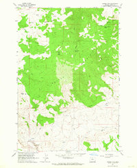
1962 Map of Mutton Mtn
USGS Topo · Published 1964About this map
The high, ridged landscape of the Mutton Mountains dominates this portion of the Warm Springs Indian Reservation, characterized by a complex network of seasonal water sources and livestock infrastructure. In the early 1960s, the terrain was defined by significant elevations such as Shaniko Butte and Mutton Mtn, with the lower reaches marked by dramatic features like Indian Head Canyon and the passage at Hellgate. The distribution of Mutton Mountain Corral, Eagle Springs Corral, and Wire Corral points to a landscape actively managed for grazing, where remote springs like Little Fawn Spring and Charley Corral Spring provided essential water. Navigation across these steep slopes relied on a system of Jeep Trails connecting the various canyons and creeks, including Skookum Creek and Eagle Creek, reflecting a period of traditional land use and controlled access within the reservation boundaries.
Find a feature on this map
21 named features on this map. Tap any name to fly to it.
Don’t see what you’re looking for? This feature index may not catch every label — zoom into the map to look around manually.
Map Details
Editions of this 1962 Mutton Mtn Map
This is the sole edition of this map. No revisions or reprints were ever made.
Other maps of this area

1928 · Madras
USGS Topo · 1:125,000

1930 · Dufur
USGS Topo · 1:125,000

1931 · Madras
USGS Topo · 1:125,000

1934 · Dufur
USGS Topo · 1:125,000

1953 · The Dalles
USGS Topo · 1:250,000

1955 · Bend
USGS Topo · 1:250,000

1956 · The Dalles
USGS Topo · 1:250,000

1957 · Bend
USGS Topo · 1:250,000

1957 · The Dalles
USGS Topo · 1:250,000

1958 · Bend
USGS Topo · 1:250,000