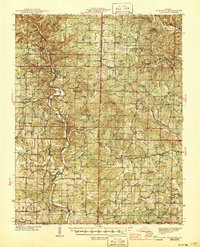
1945 Map of Gatewood
USGS Topo · Published 1945About this map
The Eleven Point River carves a deep path through the Ozark Mountains here, shaping a landscape defined by its isolated hollows and essential river crossings. Life in this portion of Mark Twain National Forest during the late 1930s and early 1940s revolved around small upland communities like Gatewood and Bardley. The map reveals a highly localized network of rural education and industry, from the timber-focused C C C Camp near Charter Oak Sch to the water-powered Thomasons Mill. Regional transit relied on river infrastructure, most notably the Stubblefield Ferry and the small Landing Field near Riverton. Genealogists will find a dense distribution of family-named landmarks and country schools, including Whitten Sch, Mitchell Sch, and Baker Sch, which served the scattered farmsteads of the Oregon and Ripley County borderlands.
Find a feature on this map
68 named features on this map. Tap any name to fly to it.
Don’t see what you’re looking for? This feature index may not catch every label — zoom into the map to look around manually.
Map Details
Editions of this 1945 Gatewood Map
3 editions found
Other maps of this area

1931 · Bandyville
USGS Topo · 1:48,000

1935 · Reyno
USGS Topo · 1:62,500

1939 · Doniphan
USGS Topo · 1:62,500

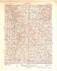
1941 · Gatewood
USGS Topo · 1:62,500

1944 · Van Buren
USGS Topo · 1:62,500

1944 · Couch
USGS Topo · 1:62,500

1944 · Birch Tree
USGS Topo · 1:62,500

1944 · Grandin
USGS Topo · 1:62,500

1945 · Doniphan
USGS Topo · 1:62,500

1945 · Gatewood
USGS Topo · 1:62,500