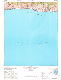
1966 Map of Gaviota
USGS Topo · Published 1966About this map
Gaviota and its dramatic coastal interface are the focus of this mid-century topographic record, where the Santa Ynez Mountains meet the Santa Barbara Channel. The coastal strip is defined by a series of steep canyons or cañadas, such as Cañada del Cementerio and Cañada del Refugio, which carry seasonal runoff from the Los Padres National Forest down to the Pacific. Transportation follows the narrow terrace between the cliffs and the sea, with the Southern Pacific railroad and Highway 101 threading through the landscape.
Find a feature on this map
29 named features on this map. Tap any name to fly to it.
Don’t see what you’re looking for? This feature index may not catch every label — zoom into the map to look around manually.
Map Details
Editions of this 1966 Gaviota Map
This is the sole edition of this map. No revisions or reprints were ever made.
Other maps of this area

1902 · Santa Ynez
USGS Topo · 1:125,000

1905 · Santa Ynez
USGS Topo · 1:125,000

1905 · Lompoc
USGS Topo · 1:125,000

1941 · San Rafael Mtn.
USGS Topo · 1:62,500

1942 · Lompoc
USGS Topo · 1:125,000

1942 · Lompoc
USGS Topo · 1:62,500

1942 · Pt. Conception
USGS Topo · 1:62,500

1942 · Gaviota
USGS Topo · 1:62,500

1942 · Goleta
USGS Topo · 1:62,500

1942 · San Rafael Mtn.
USGS Topo · 1:62,500