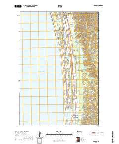
2020 Map of Gearhart
USGS Topo · Published 2020About this map
Clatsop Plains defines the low-lying coastal landscape of northern Oregon on this 2020 survey, where stabilized dunes and wetlands sit between the Pacific and the Clatsop Ridge. The map documents a complex hydrological system of interdunal lakes, including Cullaby Lake, Taylor Lake, and Slusher Lake, alongside the north-flowing Skipanon River. Historic markers of the region's development are preserved here, from the Clatsop Plains Cem to the sprawling grounds of MTA Camp Rilea. The transition from the residential street grids of Gearhart and the northern edge of Seaside to the more open Surf Pines area illustrates the modern settlement patterns along this stretch of Highway 101. Researchers will find interest in the protected lands of the Lewis and Clark National Historical Park, which bracket the coastal corridor and its various drainage creeks like Abercrombie Cr and Cullaby Cr.
Find a feature on this map
53 named features on this map. Tap any name to fly to it.
Don’t see what you’re looking for? This feature index may not catch every label — zoom into the map to look around manually.
Map Details
Editions of this 2020 Gearhart Map
This is the sole edition of this map. No revisions or reprints were ever made.
Other maps of this area

1919 · Astoria
USGS Topo · 1:62,500

1939 · Astoria
USGS Topo · 1:62,500

1940 · Cape Falcon
USGS Topo · 1:62,500

1943 · Copalis Beach
USGS Topo · 1:250,000

1948 · Vancouver
USGS Topo · 1:250,000

1949 · Astoria
USGS Topo · 1:24,000

1949 · Tillamook Head
USGS Topo · 1:24,000

1949 · Gearhart
USGS Topo · 1:24,000
1949 · Olney
USGS Topo · 1:24,000

1950 · Vancouver
USGS Topo · 1:250,000