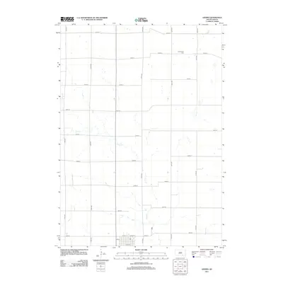
2012 Map of Geddes
USGS Topo · Published 2012About this map
Pease Cr meanders south through the center of this Charles Mix County landscape, defining the local drainage patterns between a strictly organized grid of rural roads. To the north, Morningside Cem stands as a significant landmark for genealogical research, situated just off 278th ST. The map captures the transition from open prairie and wetlands, such as Stolen Lake in the northwest, to the structured town site of Geddes. This southern settlement area is characterized by a traditional street plan featuring Jackson St, 1st St, and W 6th St. The survey reflects a region built on agricultural layout, where section lines dictate the path of travel and water remains the primary natural disruption to the geometric order of the plains.
Find a feature on this map
21 named features on this map. Tap any name to fly to it.
Don’t see what you’re looking for? This feature index may not catch every label — zoom into the map to look around manually.
Map Details
Editions of this 2012 Geddes Map
This is the sole edition of this map. No revisions or reprints were ever made.
Other maps of this area

1955 · Mitchell
USGS Topo · 1:250,000

1959 · Mitchell
USGS Topo · 1:250,000

1964 · Campbell Creek
USGS Topo · 1:24,000

1964 · Lake Andes NW
USGS Topo · 1:24,000

1964 · Lake Andes
USGS Topo · 1:24,000

1977 · Lake Andes NW
USGS Topo · 1:24,000
1977 · Lake Andes
USGS Topo · 1:24,000
1979 · Bovee
USGS Topo · 1:24,000

1979 · Geddes SE
USGS Topo · 1:24,000
1979 · Geddes
USGS Topo · 1:24,000