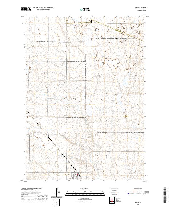
2021 Map of Geddes
USGS Topo · Published 2021About this map
The settlement of Geddes serves as the focal point in this 2021 study of the South Dakota prairie, situated near the southern edge of the quadrangle. The town's grid is clearly defined by residential streets like Michigan Ave and Iowa Ave, while the surrounding landscape reflects the vast township and range system common to the Great Plains. To the north, Stoten Lake and the winding course of Pease Cr mark the natural hydrology of the area, providing a contrast to the geometric section lines that define the local road network. The map preserves the exact boundary between Douglas and Charles Mix Counties, where Morningside Cem stands as a notable landmark for local history and genealogy. This modern topographic record captures the enduring rural character of the region, from the remote section corners to the established avenues of the town site.
Find a feature on this map
39 named features on this map. Tap any name to fly to it.
Don’t see what you’re looking for? This feature index may not catch every label — zoom into the map to look around manually.
Map Details
Editions of this 2021 Geddes Map
This is the sole edition of this map. No revisions or reprints were ever made.
Other maps of this area

1955 · Mitchell
USGS Topo · 1:250,000

1959 · Mitchell
USGS Topo · 1:250,000

1964 · Campbell Creek
USGS Topo · 1:24,000

1964 · Lake Andes NW
USGS Topo · 1:24,000

1964 · Lake Andes
USGS Topo · 1:24,000

1977 · Lake Andes NW
USGS Topo · 1:24,000
1977 · Lake Andes
USGS Topo · 1:24,000
1979 · Bovee
USGS Topo · 1:24,000

1979 · Geddes SE
USGS Topo · 1:24,000
1979 · Geddes
USGS Topo · 1:24,000