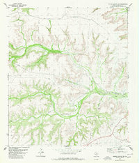
1980 Map of Geddis Canyon NW
USGS Topo · Published 1980About this map
Dry Creek snakes through the heart of this Terrell County landscape, carving a deep valley through the high desert terrain. The 1980 survey reveals a quiet but industrial corner of West Texas, defined largely by energy extraction and infrastructure rather than dense settlement. Multiple Gas Wells and an Oil Well are scattered across the southern and eastern reaches, connected by a network of pipelines that traverse the ridges and canyons. The presence of a remote Landing Strip near the creek's lower bend underscores the isolation of this region, where air travel and specialized industry equipment were essential for operations. Local landmarks like Scott and a small Gravel Pit near the southern boundary provide specific reference points for researchers studying the land use and resource management of the Trans-Pecos during the late twentieth century.
Find a feature on this map
13 named features on this map. Tap any name to fly to it.
Don’t see what you’re looking for? This feature index may not catch every label — zoom into the map to look around manually.
Map Details
Editions of this 1980 Geddis Canyon NW Map
This is the sole edition of this map. No revisions or reprints were ever made.
Other maps of this area

1928 · Sanderson
USGS Topo · 1:125,000

1929 · Sheffield
USGS Topo · 1:125,000

1929 · Independence Draw Quadrangle
USGS Topo · 1:125,000

1954 · Fort Stockton
USGS Topo · 1:250,000

1954 · Sonora
USGS Topo · 1:250,000

1958 · Sonora
USGS Topo · 1:250,000

1958 · Fort Stockton
USGS Topo · 1:250,000

1967 · Horsehead Canyon
USGS Topo · 1:24,000

1967 · Sheffield SE
USGS Topo · 1:24,000

1969 · Continental Ranch
USGS Topo · 1:24,000