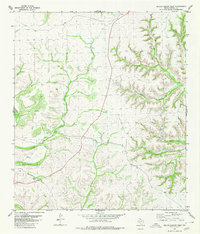
1980 Map of Geddis Canyon West
USGS Topo · Published 1980About this map
Big Canyon carves a deep path across this corner of Terrell County, illustrating the arid, dissected plateau landscape of West Texas as it appeared in the 1970s. The topography is defined by the drainage systems of Geddis Canyon and its southern fork, South Geddis Canyon, where steep-walled ravines dictate the movement of both water and people. Human infrastructure is sparse and strictly utilitarian, consisting primarily of a Jeep Trail that follows the natural contours of the high ground and a single Gravel Pit located near the canyon floor. These features, along with scattered water tanks and wells, reflect a landscape dedicated to large-scale ranching and resource extraction, where every named point on the map serves a specific functional purpose for navigating the terrain.
Find a feature on this map
7 named features on this map. Tap any name to fly to it.
Don’t see what you’re looking for? This feature index may not catch every label — zoom into the map to look around manually.
Map Details
Editions of this 1980 Geddis Canyon West Map
This is the sole edition of this map. No revisions or reprints were ever made.
Other maps of this area

1928 · Sanderson
USGS Topo · 1:125,000

1954 · Fort Stockton
USGS Topo · 1:250,000

1954 · Sonora
USGS Topo · 1:250,000

1958 · Sonora
USGS Topo · 1:250,000

1958 · Fort Stockton
USGS Topo · 1:250,000

1969 · Continental Ranch
USGS Topo · 1:24,000

1969 · Circle Dot Ranch NE
USGS Topo · 1:24,000

1969 · Dryden NE
USGS Topo · 1:24,000

1973 · Fort Stockton
USGS Topo · 1:250,000
1980 · Geddis Canyon East
USGS Topo · 1:24,000