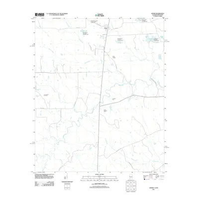
2011 Map of Geiger
USGS Topo · Published 2011About this map
Geiger serves as the primary settlement within this West Alabama landscape, situated near the Alabama-Mississippi border. The terrain is defined by a dense network of meandering waterways, including Bodka Creek, Hatchet Creek, and Factory Creek, which weave through the agricultural and timbered lands. Numerous small impoundments and named water bodies such as Williams Lake, Liars Lake, and Sibley Pond illustrate the local reliance on managed water resources. Historically significant sites for genealogists include Souls Chapel Cemetery and the extensive holdings of the Sumter Farm and Stock Company, which maintained its own infrastructure including the Sumter Farms and Stock Company Inc Airport. The map also documents modern industrial presence with the Emelle Treatment Facility, providing a clear look at how land use in Sumter County has evolved between traditional farming and contemporary utility needs.
Find a feature on this map
40 named features on this map. Tap any name to fly to it.
Don’t see what you’re looking for? This feature index may not catch every label — zoom into the map to look around manually.
Map Details
Editions of this 2011 Geiger Map
This is the sole edition of this map. No revisions or reprints were ever made.
Other maps of this area

1929 · Epes
USGS Topo · 1:48,000

1932 · Epes
USGS Topo · 1:62,500

1953 · Meridian
USGS Topo · 1:250,000

1957 · Meridian
USGS Topo · 1:250,000

1965 · Meridian
USGS Topo · 1:250,000

1970 · Gainesville
USGS Topo · 1:24,000

1970 · Warsaw
USGS Topo · 1:24,000

1973 · Panola
USGS Topo · 1:24,000

1973 · Scooba
USGS Topo · 1:24,000
1973 · Geiger
USGS Topo · 1:24,000