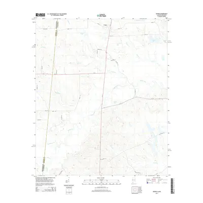
2014 Map of Geiger
USGS Topo · Published 2014About this map
The town of Geiger sits at the northern edge of this survey, positioned near the intersection of several local routes in Sumter County. The surrounding landscape is defined by an intricate network of waterways, including Bodka Creek and its many tributaries like Tifallili Cr and Shy Hammock Cr. This drainage pattern creates a terrain of numerous small basins, often occupied by family-named water bodies such as Williams Lake and C E Boyd Pond.
Find a feature on this map
42 named features on this map. Tap any name to fly to it.
Don’t see what you’re looking for? This feature index may not catch every label — zoom into the map to look around manually.
Map Details
Editions of this 2014 Geiger Map
This is the sole edition of this map. No revisions or reprints were ever made.
Other maps of this area

1929 · Epes
USGS Topo · 1:48,000

1932 · Epes
USGS Topo · 1:62,500

1953 · Meridian
USGS Topo · 1:250,000

1957 · Meridian
USGS Topo · 1:250,000

1965 · Meridian
USGS Topo · 1:250,000

1970 · Gainesville
USGS Topo · 1:24,000

1970 · Warsaw
USGS Topo · 1:24,000

1973 · Panola
USGS Topo · 1:24,000

1973 · Scooba
USGS Topo · 1:24,000
1973 · Geiger
USGS Topo · 1:24,000