
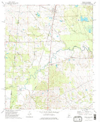
2020 Map of Geiger
USGS Topo · Published 2020About this map
The settlement of Geiger sits at the northern edge of this landscape, where the state boundary between the Mississippi Alabama line and the junction of Kemper and Sumter counties meet. This region is defined by a dense network of winding watercourses, including the extensive reaches of Bodka Creek and Hatchet Cr. Local landmarks like Souls Chapel Cem serve as important points for genealogical research, situated amidst the rural road networks of Old Bodka Rd and Henderson Rd. The terrain is punctuated by numerous named bodies of water such as Williams Lake, Liars Lake, and New Big Lake, reflecting a well-watered environment that has shaped the local land use and boundary lines. The map captures the interface of established township and range lines, such as t22n r4w and t21n r3w, illustrating the precise surveying of this borderland area.
Find a feature on this map
43 named features on this map. Tap any name to fly to it.
Don’t see what you’re looking for? This feature index may not catch every label — zoom into the map to look around manually.
Map Details
Editions of this 2020 Geiger Map
This is the sole edition of this map. No revisions or reprints were ever made.
Other maps of this area

1929 · Epes
USGS Topo · 1:48,000

1932 · Epes
USGS Topo · 1:62,500

1953 · Meridian
USGS Topo · 1:250,000

1957 · Meridian
USGS Topo · 1:250,000

1965 · Meridian
USGS Topo · 1:250,000

1970 · Gainesville
USGS Topo · 1:24,000

1970 · Warsaw
USGS Topo · 1:24,000

1973 · Panola
USGS Topo · 1:24,000

1973 · Scooba
USGS Topo · 1:24,000
1973 · Geiger
USGS Topo · 1:24,000