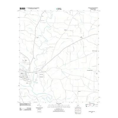
2011 Map of Geneva East
USGS Topo · Published 2011About this map
Geneva and the neighboring community of Eunola anchor this study of the landscape where the Pea River meets the Choctawhatchee River. The convergence of these significant waterways has long shaped the settlement patterns of Geneva County, visible here through the placement of early burial grounds like Geneva City Cemetery and Eunola Cemetery. Beyond the river junction, the terrain transitions into a patchwork of rural holdings and smaller watercourses such as Simmons Creek and Spring Creek.
Find a feature on this map
94 named features on this map. Tap any name to fly to it.
Don’t see what you’re looking for? This feature index may not catch every label — zoom into the map to look around manually.
Map Details
Editions of this 2011 Geneva East Map
This is the sole edition of this map. No revisions or reprints were ever made.
Other maps of this area

1942 · Enterprise
USGS Topo · 1:125,000

1949 · Hobbs Crossroads
USGS Topo · 1:24,000

1950 · Hobbs Cross Roads
USGS Topo · 1:24,000

1950 · Izagora
USGS Topo · 1:24,000

1950 · Esto
USGS Topo · 1:24,000

1951 · Esto
USGS Topo · 1:24,000

1953 · Dothan
USGS Topo · 1:250,000

1954 · Dothan
USGS Topo · 1:250,000

1954 · Tallahassee
USGS Topo · 1:250,000

1955 · Dothan
USGS Topo · 1:250,000