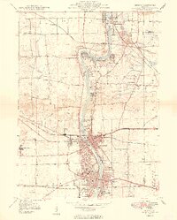
1949 Map of Geneva
USGS Topo · Published 1949About this map
The Fox River corridor serves as the industrial and social backbone of this Kane County region, flowing past the expanding mid-century centers of St Charles and Geneva. Post-war development is evident along the riverbanks, where landmarks like Dunham Castle and Pottawatomie Park stand alongside institutional sites such as the State Boys School and the State Girls School. The landscape is etched with the paths of major railroads, including the Chicago and North Western and the Chicago Great Western, which shaped the area's transition from agricultural to suburban industrial hubs. A network of rural one-room schools, including Red Brick Sch and Peck School, remains visible across the townships, documenting the educational history of the surrounding countryside before modern consolidation. Numerous religious and civic sites, from the Sacred Heart Seminary to Good Templar Park, illustrate the diverse community anchors that defined this river valley in the late 1940s.
Find a feature on this map
46 named features on this map. Tap any name to fly to it.
Don’t see what you’re looking for? This feature index may not catch every label — zoom into the map to look around manually.
Map Details
Editions of this 1949 Geneva Map
2 editions found
Other maps of this area

1908 · Wheaton
USGS Topo · 1:62,500

1923 · Barrington
USGS Topo · 1:62,500

1925 · Elgin
USGS Topo · 1:62,500

1932 · Geneva
USGS Topo · 1:62,500

1935 · Barrington
USGS Topo · 1:62,500

1940 · Elgin
USGS Topo · 1:62,500

1948 · Wheaton
USGS Topo · 1:62,500

1948 · Geneva
USGS Topo · 1:62,500

1949 · Geneva
USGS Topo · 1:24,000

1950 · Aurora North
USGS Topo · 1:24,000