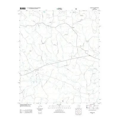
2012 Map of Geneva
USGS Topo · Published 2012About this map
Palo Gaucho Bayou winds through the heart of this East Texas landscape, which is characterized by a dense network of family cemeteries and historic crossroads. The map documents the rural settlement of Geneva and the surrounding woodlands where numerous creeks, including Tiger Cr, Tebo Cr, and Boregas Cr, drain toward the bayou system. The abundance of burial sites, such as McMahon's Chapel Cem and Meador-Judson Meador Cem, reflects a deeply rooted local genealogy and a pattern of dispersed community centers. Elevated terrain like Rosin Ridge rises above the watercourses of Beech Cr and Sulphur Cr, illustrating the subtle topography of Sabine County. This record captures the intricate system of local lanes and farm-to-market roads, such as Lick Skillet Rd and W Carters Ferry Rd, that connect these historic settlements.
Find a feature on this map
61 named features on this map. Tap any name to fly to it.
Don’t see what you’re looking for? This feature index may not catch every label — zoom into the map to look around manually.
Map Details
Editions of this 2012 Geneva Map
This is the sole edition of this map. No revisions or reprints were ever made.
Other maps of this area

1944 · Patroon
USGS Topo · 1:62,500

1953 · Alexandria
USGS Topo · 1:250,000

1953 · Palestine
USGS Topo · 1:250,000

1955 · Alexandria
USGS Topo · 1:250,000

1956 · Patroon
USGS Topo · 1:62,500

1957 · Palestine
USGS Topo · 1:250,000

1958 · Hemphill
USGS Topo · 1:62,500

1958 · San Augustine
USGS Topo · 1:62,500

1958 · Bronson
USGS Topo · 1:62,500
1984 · Milam
USGS Topo · 1:24,000