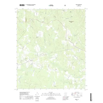
2019 Map of Geneva
USGS Topo · Published 2019About this map
Rosevine serves as a central hub for this portion of the East Texas timberlands, situated near the boundary line of San Augustine and Sabine counties. The landscape is defined by the dense woodlands of the Sabine National Forest and a complex drainage system led by Palo Gaucho Bayou and Tebo Creek. The area’s historical depth is evident in its numerous family and community burial grounds, such as McMahon's Chapel Cem and the King Family Cem. The terrain rises toward the south at Rosin Ridge, overlooking a network of creeks like Donahue Creek and Rocky Creek. This survey reveals a pattern of rural settlement where small communities and churches are connected by routes such as FM 1592 and Rosevine Road, illustrating the enduring agricultural and forest-based character of the region.
Find a feature on this map
82 named features on this map. Tap any name to fly to it.
Don’t see what you’re looking for? This feature index may not catch every label — zoom into the map to look around manually.
Map Details
Editions of this 2019 Geneva Map
This is the sole edition of this map. No revisions or reprints were ever made.
Other maps of this area

1944 · Patroon
USGS Topo · 1:62,500

1953 · Alexandria
USGS Topo · 1:250,000

1953 · Palestine
USGS Topo · 1:250,000

1955 · Alexandria
USGS Topo · 1:250,000

1956 · Patroon
USGS Topo · 1:62,500

1957 · Palestine
USGS Topo · 1:250,000

1958 · Hemphill
USGS Topo · 1:62,500

1958 · San Augustine
USGS Topo · 1:62,500

1958 · Bronson
USGS Topo · 1:62,500
1984 · Milam
USGS Topo · 1:24,000