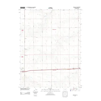
2013 Map of Genoa East
USGS Topo · Published 2013About this map
The town of Genoa and the settlement of Bovina anchor this High Plains landscape, where the Jeffersonian grid of county roads meets the winding courses of intermittent prairie streams. The area is defined by its deep roots in the local community, evidenced by several distinct burial grounds including the Genoa Community Cem, the Genoa Lutheran Cem, and the Bovina Cem. These sites, along with the Lutheran Cem to the north, offer valuable data points for genealogists tracing families in Lincoln County. The drainage network, characterized by Hell Cr, Hackberry Cr, and Dugout Cr, carves subtle relief into the terrain, while Dugout Springs suggests the critical importance of water sources in this semi-arid region. Modern transportation corridors like Frontage Rd follow the historical path of movement through this part of eastern Colorado.
Find a feature on this map
34 named features on this map. Tap any name to fly to it.
Don’t see what you’re looking for? This feature index may not catch every label — zoom into the map to look around manually.
Map Details
Editions of this 2013 Genoa East Map
This is the sole edition of this map. No revisions or reprints were ever made.
Other maps of this area

1891 · Limon
USGS Topo · 1:125,000

1892 · Limon
USGS Topo · 1:125,000

1954 · Limon
USGS Topo · 1:250,000

1957 · Limon
USGS Topo · 1:250,000

1958 · Limon
USGS Topo · 1:250,000

1979 · Arriba NW
USGS Topo · 1:24,000

1979 · Sevenmile Ranch
USGS Topo · 1:24,000

1979 · Arriba
USGS Topo · 1:24,000
1979 · Barron Creek
USGS Topo · 1:24,000

1979 · Genoa East
USGS Topo · 1:24,000