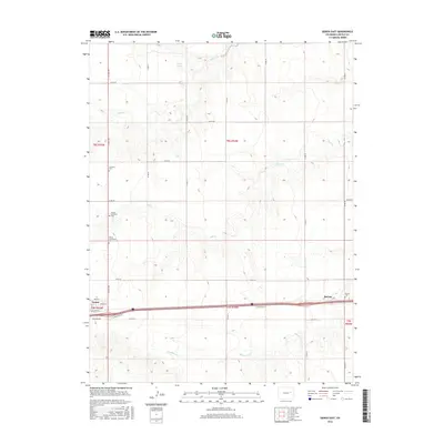
2016 Map of Genoa East
USGS Topo · Published 2016About this map
Genoa serves as the primary focal point of this Eastern Colorado landscape, situated along the path of Old Hwy 24 and the modern Interstate 70 corridor. The map reveals a high-plains topography defined by intermittent watercourses like Hell Cr and Hackberry Cr, which carve shallow draws across the township and range sections. For genealogical research, the area is notably dense with burial sites including the Genoa Lutheran Cem, Genoa Community Cem, and the Lutheran Cem north of town. To the east, the small community of Bovina is marked near the Bovina Cem. The presence of Dugout Springs near Dugout Cr indicates the historical importance of reliable water sources in this arid ranching and farming environment, where a grid of county roads such as Co Rd 32 and Co Rd 35 connects isolated farmsteads.
Find a feature on this map
37 named features on this map. Tap any name to fly to it.
Don’t see what you’re looking for? This feature index may not catch every label — zoom into the map to look around manually.
Map Details
Editions of this 2016 Genoa East Map
This is the sole edition of this map. No revisions or reprints were ever made.
Other maps of this area

1891 · Limon
USGS Topo · 1:125,000

1892 · Limon
USGS Topo · 1:125,000

1954 · Limon
USGS Topo · 1:250,000

1957 · Limon
USGS Topo · 1:250,000

1958 · Limon
USGS Topo · 1:250,000

1979 · Arriba NW
USGS Topo · 1:24,000

1979 · Sevenmile Ranch
USGS Topo · 1:24,000

1979 · Arriba
USGS Topo · 1:24,000
1979 · Barron Creek
USGS Topo · 1:24,000

1979 · Genoa East
USGS Topo · 1:24,000