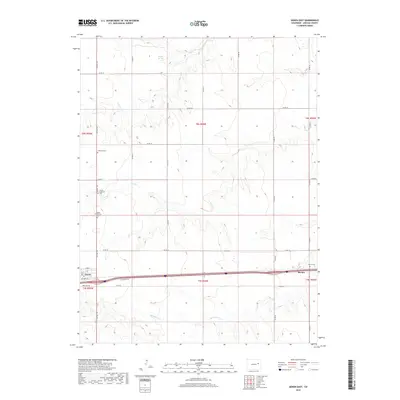
2019 Map of Genoa East
USGS Topo · Published 2019About this map
Genoa and the nearby settlement of Bovina anchor this Lincoln County landscape, situated along the southern edge of the sheet. The area is defined by its deep genealogical roots, evidenced by four distinct burial grounds: the Lutheran Cem, Genoa Lutheran Cem, Genoa Community Cem, and Bovina Cem. These sites speak to the enduring community structure of the Colorado high plains. The topography is shaped by an intermittent drainage network, with the headwaters of Hell Cr and Dugout Cr carving subtle relief across the terrain. Of particular interest is the presence of Dugout Springs in the northern reaches, a vital water source in this semi-arid region. The map captures a grid-based transportation system typical of the agricultural West, where Co HWY 109 and a network of county roads intersect the interstate corridor.
Find a feature on this map
33 named features on this map. Tap any name to fly to it.
Don’t see what you’re looking for? This feature index may not catch every label — zoom into the map to look around manually.
Map Details
Editions of this 2019 Genoa East Map
This is the sole edition of this map. No revisions or reprints were ever made.
Other maps of this area

1891 · Limon
USGS Topo · 1:125,000

1892 · Limon
USGS Topo · 1:125,000

1954 · Limon
USGS Topo · 1:250,000

1957 · Limon
USGS Topo · 1:250,000

1958 · Limon
USGS Topo · 1:250,000

1979 · Arriba NW
USGS Topo · 1:24,000

1979 · Sevenmile Ranch
USGS Topo · 1:24,000

1979 · Arriba
USGS Topo · 1:24,000
1979 · Barron Creek
USGS Topo · 1:24,000

1979 · Genoa East
USGS Topo · 1:24,000