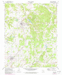
1971 Map of Gentry
USGS Topo · Published 1982About this map
Kansas City Southern rail lines anchor the agricultural and industrial landscape of western Benton County, connecting the established hubs of Decatur and Gentry. This 1970s survey, updated with early 1980s data, reveals a region defined by its water resources and transport networks. To the north and east, the topography becomes more complex, carved by South Prong Spavinaw Creek and the deep incisions of Columbia Hollow and Grape Hollow. The presence of the Crystal Lake Airport and several Fish Hatchery sites speaks to the local economy and land use during this period. Local history and genealogy are well-represented by long-standing community markers like Midway Church, Bethel Heights Church, and the Gentry Cemetery. Small-scale infrastructure, including a Gaging Station on Flint Creek and various ponds, illustrates the management of the many branches and creeks that feed the Springtown area.
Find a feature on this map
25 named features on this map. Tap any name to fly to it.
Don’t see what you’re looking for? This feature index may not catch every label — zoom into the map to look around manually.
Map Details
Editions of this 1971 Gentry Map
2 editions found
Other maps of this area

1899 · Fayetteville
USGS Topo · 1:125,000

1899 · Siloam Springs
USGS Topo · 1:125,000

1901 · Fayetteville
USGS Topo · 1:125,000

1903 · Siloam Springs
USGS Topo · 1:125,000

1904 · Siloam Springs
USGS Topo · 1:125,000

1904 · Fayetteville
USGS Topo · 1:125,000

1954 · Tulsa
USGS Topo · 1:250,000

1958 · Tulsa
USGS Topo · 1:250,000

1963 · Tulsa
USGS Topo · 1:250,000

1970 · Gallatin
USGS Topo · 1:24,000