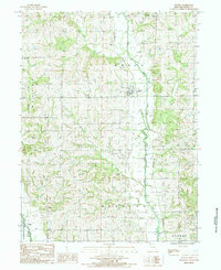
1984 Map of Gentry
USGS Topo · Published 1985About this map
The Middle Fork Grand River defines the central axis of this landscape, its winding course accompanied by extensive sand deposits as it flows through the heart of Gentry County. The settlement of Gentry serves as the primary focal point, situated near a distinctive bend in the river where several local drainage systems, including Linn Creek and Peddler Creek, converge. A significant archaeological and historical remnant, the Old Railroad Grade, runs parallel to the river valley, marking the path of former transportation routes that once connected these rural townships.
Find a feature on this map
15 named features on this map. Tap any name to fly to it.
Don’t see what you’re looking for? This feature index may not catch every label — zoom into the map to look around manually.
Map Details
Editions of this 1984 Gentry Map
This is the sole edition of this map. No revisions or reprints were ever made.
Other maps of this area

1925 · Stanberry
USGS Topo · 1:62,500

1925 · Darlington
USGS Topo · 1:62,500

1939 · Stanberry
USGS Topo · 1:62,500

1940 · Parnell
USGS Topo · 1:62,500

1942 · Grant City
USGS Topo · 1:62,500

1943 · Parnell
USGS Topo · 1:62,500

1943 · Grant City
USGS Topo · 1:62,500

1943 · Stanberry
USGS Topo · 1:62,500

1950 · Darlington
USGS Topo · 1:62,500

1955 · Nebraska City
USGS Topo · 1:250,000