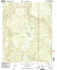
2004 Map of Gentry Mountain
USGS Topo · Published 2006About this map
Q Ranch sits at the heart of this high-country landscape, positioned near the boundary where the Tonto National Forest meets the Fort Apache Indian Reservation. The terrain is defined by dramatic elevation changes, moving from the heights of Gentry Mountain and Shell Mountain down into the deep incision of Gentry Canyon. This area is heavily marked by small-scale resource extraction and early settlement infrastructure, evidenced by numerous Prospect sites, Adit locations, and scattered corrals. Water management is a central theme of the geography here, with a dense network of developed springs and tanks such as Cunningham Spring, Cem Spring, and the Clover Flat Tank system. These features, along with the Second Standard Parallel North, reflect the historical efforts to survey and utilize the remote Arizona interior for ranching and mineral exploration during the late 20th century.
Find a feature on this map
63 named features on this map. Tap any name to fly to it.
Don’t see what you’re looking for? This feature index may not catch every label — zoom into the map to look around manually.
Map Details
Editions of this 2004 Gentry Mountain Map
This is the sole edition of this map. No revisions or reprints were ever made.
Other maps of this area

1886 · Holbrook
USGS Topo · 1:250,000

1893 · Holbrook
USGS Topo · 1:250,000

1922 · Chrysotile
USGS Topo · 1:125,000

1946 · Blue House Mtn
USGS Topo · 1:62,500

1949 · McFadden Peak
USGS Topo · 1:62,500

1950 · McFadden Peak
USGS Topo · 1:62,500

1951 · Blue House Mtn
USGS Topo · 1:62,500

1954 · Holbrook
USGS Topo · 1:250,000

1954 · Mesa
USGS Topo · 1:250,000

1957 · Mesa
USGS Topo · 1:250,000