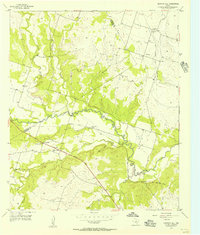
1956 Map of Gentrys Mill
USGS Topo · Published 1957About this map
The Leon River carves through the central landscape of this mid-1950s survey, marking a borderland between Hamilton and Comanche counties. The terrain is defined by a dense network of seasonal drainages, including Warren Creek, Pecan Creek, and Resley Creek, which feed into the main river valley. Rural life in this era centered on small communities and family-named landmarks, such as the cluster of activity around Gentrys Mill, where both the local Gentrys Mill Ch and Warren Creek Ch served the surrounding farmsteads. The infrastructure reflects a period of transition; while the 36th Division Memorial Highway provides modern transit, the presence of an Old Railroad Grade and the notation for Springtown (Aband) point to the shifting economic centers of the early 20th century. Genealogists will find several burial sites preserved here, including Fuqua Cem and Toliver Cem.
Find a feature on this map
26 named features on this map. Tap any name to fly to it.
Don’t see what you’re looking for? This feature index may not catch every label — zoom into the map to look around manually.
Map Details
Editions of this 1956 Gentrys Mill Map
2 editions found
Other maps of this area

1888 · Hamilton
USGS Topo · 1:125,000

1894 · Hamilton
USGS Topo · 1:125,000

1954 · Brownwood
USGS Topo · 1:250,000

1956 · Gustine
USGS Topo · 1:62,500

1956 · Gentrys Mill
USGS Topo · 1:24,000

1956 · Pottsville
USGS Topo · 1:62,500

1956 · Hico
USGS Topo · 1:62,500

1956 · Hamilton
USGS Topo · 1:62,500

1956 · Hamilton West
USGS Topo · 1:24,000
1956 · Eidson Lake
USGS Topo · 1:24,000