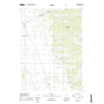
2020 Map of Georgetown
USGS Topo · Published 2020About this map
Georgetown and Bennington anchor the western edge of the Preuss Range, where the steep mountain front meets the agricultural expanses of the Bear Lake Valley. The landscape is defined by a series of deep drainages carved into the eastern highlands, including Georgetown Canyon, Maple Canyon, and Red Canyon, which transition from the high-elevation peaks of the Caribou National Forest down toward the Bear River. This geography highlights the 19th-century settlement patterns of the region, where communities developed along the reliable water sources of Georgetown Creek and Threemile Creek.
Find a feature on this map
60 named features on this map. Tap any name to fly to it.
Don’t see what you’re looking for? This feature index may not catch every label — zoom into the map to look around manually.
Map Details
Editions of this 2020 Georgetown Map
This is the sole edition of this map. No revisions or reprints were ever made.
Other maps of this area

1909 · Montpelier
USGS Topo · 1:125,000

1911 · Montpelier
USGS Topo · 1:125,000

1911 · Slug Creek
USGS Topo · 1:62,500

1915 · Crow Creek
USGS Topo · 1:62,500

1949 · Snowdrift Mountain
USGS Topo · 1:24,000
1951 · Snowdrift Mountain
USGS Topo · 1:24,000

1955 · Preston
USGS Topo · 1:250,000

1958 · Preston
USGS Topo · 1:250,000

1962 · Preston
USGS Topo · 1:250,000

1967 · Montpelier
USGS Topo · 1:24,000