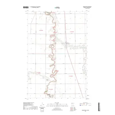
2019 Map of Georgetown
USGS Topo · Published 2019About this map
The Red River of the North winds in tight oxbows along the border of North Dakota and Minnesota, defining the western edge of the settlement at Georgetown. This fertile prairie landscape is deeply connected to its agricultural roots, where the confluence of the Buffalo River and the main channel dictated early land use. The map reveals the intricate water network of the Red River Valley, including the Sheyenne River and the managed flow of County Ditch Number Twentythree-B. Local heritage is anchored by significant community landmarks such as Osterdalen Lutheran Church and its accompanying Osterdalen Church Cem. Further north, the Nora South Pioneer Cem sits near the riverbanks, marking the locations where early families established themselves in this riverine corridor.
Find a feature on this map
55 named features on this map. Tap any name to fly to it.
Don’t see what you’re looking for? This feature index may not catch every label — zoom into the map to look around manually.
Map Details
Editions of this 2019 Georgetown Map
This is the sole edition of this map. No revisions or reprints were ever made.
Other maps of this area

1895 · Fargo
USGS Topo · 1:125,000

1897 · Fargo
USGS Topo · 1:125,000

1952 · Grand Forks
USGS Topo · 1:250,000

1953 · Fargo
USGS Topo · 1:250,000

1956 · Fargo
USGS Topo · 1:250,000

1956 · Grand Forks
USGS Topo · 1:250,000

1959 · Fargo North
USGS Topo · 1:24,000

1959 · West Fargo
USGS Topo · 1:24,000

1963 · Georgetown
USGS Topo · 1:24,000
1963 · Argusville
USGS Topo · 1:24,000