
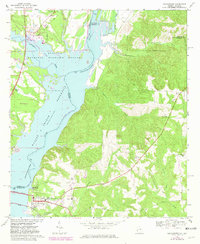
1967 Map of Georgetown
USGS Topo · Published 1970About this map
Georgetown anchors the southwest corner of this 1960s landscape, situated where the Central of Georgia railroad line and the Vandiver Causeway cross the expansive Walter F George Reservoir. This period of the mid-twentieth century reflects a significant transformation of the Chattahoochee River valley into a managed waterway, evidenced by the broad reaches of the Eufaula National Wildlife Refuge and numerous recreational zones like River Bluff Recreation Area. East of the water, the terrain rises into the dissected uplands of Quitman Co, where local life is marked by rural landmarks such as Keglar Sch, Liberty Ch, and the Bumbleton Courthouse Cem. The transition from the river bottomlands to the wooded ridges is further highlighted by the Quitman Lookout Tower overlooking the winding paths of Soapstone Creek and Bustahatchee Creek.
Find a feature on this map
31 named features on this map. Tap any name to fly to it.
Don’t see what you’re looking for? This feature index may not catch every label — zoom into the map to look around manually.
Map Details
Editions of this 1967 Georgetown Map
2 editions found
Other maps of this area

1950 · Lumpkin SW
USGS Topo · 1:24,000

1950 · Lumpkin
USGS Topo · 1:62,500

1953 · Dothan
USGS Topo · 1:250,000

1954 · Dothan
USGS Topo · 1:250,000

1955 · Dothan
USGS Topo · 1:250,000

1955 · Lumpkin SW
USGS Topo · 1:24,000

1955 · Lumpkin
USGS Topo · 1:62,500

1955 · Phenix City
USGS Topo · 1:250,000

1957 · Phenix City
USGS Topo · 1:250,000

1958 · Phenix City
USGS Topo · 1:250,000