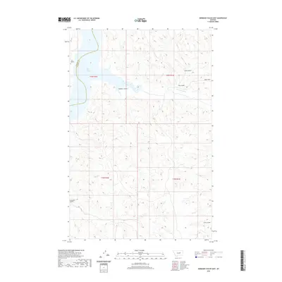
2020 Map of Germaine Coulee East
USGS Topo · Published 2020About this map
Fort Peck Lake defines the northern reaches of this Garfield County landscape, where the waters of the U L Bend meet a complex network of dry drainage systems. The terrain is characterized by these intricate coulees, including Sandburn Coulee and Grass Coulee, which carve through the high plains toward the Missouri River reservoir. The boundary between Phillips Co and Garfield Co runs directly through the lake, marking a jurisdictional divide in this sparsely settled region.
Find a feature on this map
14 named features on this map. Tap any name to fly to it.
Don’t see what you’re looking for? This feature index may not catch every label — zoom into the map to look around manually.
Map Details
Editions of this 2020 Germaine Coulee East Map
This is the sole edition of this map. No revisions or reprints were ever made.
Other maps of this area

1954 · Jordan
USGS Topo · 1:250,000

1956 · Jordan
USGS Topo · 1:250,000

1958 · Jordan
USGS Topo · 1:250,000

1964 · Jordan
USGS Topo · 1:250,000

1965 · Germaine Coulee East
USGS Topo · 1:24,000

1965 · Germaine Coulee West
USGS Topo · 1:24,000

1965 · Lost Creek
USGS Topo · 1:24,000

1965 · Locke Ranch
USGS Topo · 1:24,000

1965 · Cap Rock Butte
USGS Topo · 1:24,000
1965 · Mickey Butte
USGS Topo · 1:24,000