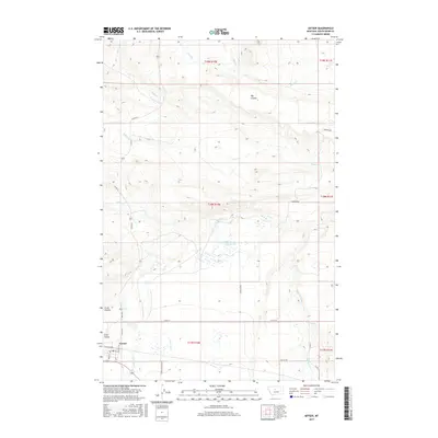
2017 Map of Geyser
USGS Topo · Published 2017About this map
Geyser anchors this corner of Judith Basin County, serving as a hub for the surrounding ranching and agricultural landscape. The town site is clearly defined by a grid including Main St, Hill Ave, and Railroad Ave, reflecting its historical connection to the rail corridor. The surrounding terrain is deeply etched by a complex drainage network, where Arrow Cr and its tributaries like Hay Cr and Lone Tree Cr carve through the high plains. Water resources are localized at points such as Arrow Creek Spring and Big Flat Spring, which would have been vital landmarks for early settlement and stock management. Notable landforms like Big Coulee and Crow Coulee dominate the topography, illustrating the erosional character of the northern Montana landscape. The map also traces a network of county roads, such as Co RD 201 and Spencer Rd, that follow the township and range lines established by the Public Land Survey System.
Find a feature on this map
35 named features on this map. Tap any name to fly to it.
Don’t see what you’re looking for? This feature index may not catch every label — zoom into the map to look around manually.
Map Details
Editions of this 2017 Geyser Map
This is the sole edition of this map. No revisions or reprints were ever made.
Other maps of this area

1890 · Fort Benton
USGS Topo · 1:250,000

1892 · Fort Benton
USGS Topo · 1:250,000

1897 · Fort Benton
USGS Topo · 1:250,000

1954 · Great Falls
USGS Topo · 1:250,000

1957 · Great Falls
USGS Topo · 1:250,000
1961 · The Arch
USGS Topo · 1:24,000

1961 · Barker
USGS Topo · 1:62,500

1978 · Arrow Peak
USGS Topo · 1:24,000

1978 · Leiberg Coulee
USGS Topo · 1:24,000
1978 · Byrne Creek
USGS Topo · 1:24,000