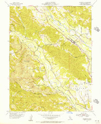
1955 Map of Geyserville
USGS Topo · Published 1956About this map
Alexander Valley is the primary focus of this mid-century topographic survey, where the Russian River and the Northwestern Pacific railroad define the transportation and agricultural corridor of northern Sonoma County. The settlement of Geyserville sits at the heart of this landscape, flanked by the smaller rail stops of Chianti and Nervo. To the west, the terrain rises sharply toward Bradford Mtn, where numerous creek branches like Dry Creek and Pena Creek drain the steep ridges. The map captures a moment of established rural infrastructure, noting local gathering places such as the Grange Hall and Manzanita School. Unique social history is preserved through the labeling of the Lytton Industrial Home and the Olive Hill Cemetery, providing valuable points of reference for genealogists and local historians studying the evolution of land use and community institutions in the region.
Find a feature on this map
40 named features on this map. Tap any name to fly to it.
Don’t see what you’re looking for? This feature index may not catch every label — zoom into the map to look around manually.
Map Details
Editions of this 1955 Geyserville Map
4 editions found
Other maps of this area

1920 · Healdsburg
USGS Topo · 1:62,500

1921 · Skaggs
USGS Topo · 1:62,500

1921 · Kelseyville
USGS Topo · 1:62,500

1933 · Healdsburg
USGS Topo · 1:48,000

1938 · Hopland
USGS Topo · 1:62,500

1940 · Healdsburg
USGS Topo · 1:62,500

1943 · Cazadero
USGS Topo · 1:24,000

1943 · Skaggs Springs
USGS Topo · 1:24,000

1943 · Kelseyville
USGS Topo · 1:62,500

1943 · Hopland
USGS Topo · 1:62,500