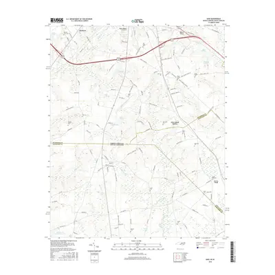
2016 Map of Ghio
USGS Topo · Published 2016About this map
Ghio Scholl Station sits at the heart of this landscape straddling the Richmond and Scotland county lines, just north of the border between North Carolina and South Carolina. The area is defined by a complex network of wetlands and ponds, including Krinshaw Pond, Honeysucker Pond, and the expansive Pates Lake Number Two. These water bodies feed into meandering runs like Lightwood Knot Cr and Crooked Cr, which historically influenced the placement of early settlements and road networks.
Find a feature on this map
124 named features on this map. Tap any name to fly to it.
Don’t see what you’re looking for? This feature index may not catch every label — zoom into the map to look around manually.
Map Details
Editions of this 2016 Ghio Map
This is the sole edition of this map. No revisions or reprints were ever made.
Other maps of this area

1942 · Rockingham
USGS Topo · 1:125,000

1949 · Gibson
USGS Topo · 1:24,000

1949 · Ghio
USGS Topo · 1:24,000

1949 · Marston
USGS Topo · 1:24,000

1949 · Hamlet
USGS Topo · 1:24,000

1949 · Hamlet
USGS Topo · 1:62,500

1953 · Florence
USGS Topo · 1:250,000

1954 · Florence
USGS Topo · 1:250,000
1956 · Rockingham
USGS Topo · 1:24,000
1957 · Hamlet
USGS Topo · 1:24,000