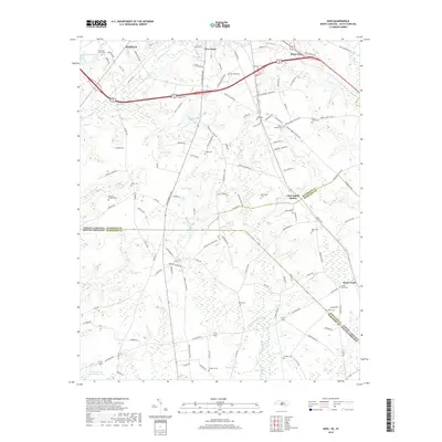
2019 Map of Ghio
USGS Topo · Published 2019About this map
The borderlands between North Carolina and South Carolina are defined here by a dense network of small rural settlements and family cemeteries. Hamlet serves as a primary hub in the northern portion, giving way to smaller clusters like New Town, Steen Town, and the distinctive Ghio Scholl Station near the county line. The landscape is heavily marked by water management and natural drainage, with various impoundments such as Battley Pond, James Pond, and Usher Pond dotting the terrain.
Find a feature on this map
127 named features on this map. Tap any name to fly to it.
Don’t see what you’re looking for? This feature index may not catch every label — zoom into the map to look around manually.
Map Details
Editions of this 2019 Ghio Map
This is the sole edition of this map. No revisions or reprints were ever made.
Other maps of this area

1942 · Rockingham
USGS Topo · 1:125,000

1949 · Gibson
USGS Topo · 1:24,000

1949 · Ghio
USGS Topo · 1:24,000

1949 · Marston
USGS Topo · 1:24,000

1949 · Hamlet
USGS Topo · 1:24,000

1949 · Hamlet
USGS Topo · 1:62,500

1953 · Florence
USGS Topo · 1:250,000

1954 · Florence
USGS Topo · 1:250,000
1956 · Rockingham
USGS Topo · 1:24,000
1957 · Hamlet
USGS Topo · 1:24,000