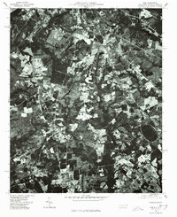
1976 Map of Ghio
USGS Topo · Published 1978About this map
Ghio sits along the North Carolina and South Carolina border in this 1976 orthophotograph, surrounded by a patchwork of agricultural clearings and dense woodland. This specialized imagery, prepared by the Department of Natural and Economic Resources and the USGS, provides a direct visual record of the land use during the mid-1970s. The settlement patterns are concentrated in clusters like New Town and Stern Town, where the landscape transitions from managed timber tracts to small family farms. Water resources are represented by features such as Krinshaw Pond, which serves as a central landmark in the western half of the quadrangle. The map captures the rural character of Richmond County before significant modern development, showing the precise footprints of dwellings and the layout of local roads that define these communities.
Find a feature on this map
4 named features on this map. Tap any name to fly to it.
Don’t see what you’re looking for? This feature index may not catch every label — zoom into the map to look around manually.
Map Details
Editions of this 1976 Ghio Map
This is the sole edition of this map. No revisions or reprints were ever made.
Other maps of this area

1942 · Rockingham
USGS Topo · 1:125,000

1949 · Gibson
USGS Topo · 1:24,000

1949 · Ghio
USGS Topo · 1:24,000

1949 · Marston
USGS Topo · 1:24,000

1949 · Hamlet
USGS Topo · 1:24,000

1949 · Hamlet
USGS Topo · 1:62,500

1953 · Florence
USGS Topo · 1:250,000

1954 · Florence
USGS Topo · 1:250,000
1956 · Rockingham
USGS Topo · 1:24,000
1957 · Hamlet
USGS Topo · 1:24,000