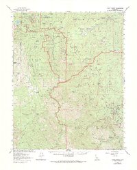
1956 Map of Giant Forest
USGS Topo · Published 1984About this map
Kings Canyon National Park and Sequoia National Park meet in this mid-century survey, showcasing a landscape defined by massive groves and early forest management. High-elevation settlements like Wilsonia and Hartland appear alongside recreational infrastructure that was becoming permanent during the 1950s. The presence of the Whitaker Forest (Univ of Calif) indicates the area's long-standing importance for botanical research. The Generals Highway serves as the primary artery through the high country, connecting points such as the Big Stump Entrance Station to the deep river valleys of the Marble Fork Kaweah River. Dozens of meadows and campgrounds, including Potwisha Campground and Buckeye Flat Campground, illustrate the transition of this timber-rich region into a premier destination for backcountry exploration and scientific study during the post-war era.
Find a feature on this map
105 named features on this map. Tap any name to fly to it.
Don’t see what you’re looking for? This feature index may not catch every label — zoom into the map to look around manually.
Map Details
Editions of this 1956 Giant Forest Map
4 editions found

Other maps of this area

1903 · Tehipite
USGS Topo · 1:125,000

1904 · Kaweah
USGS Topo · 1:125,000

1905 · Tehipite
USGS Topo · 1:125,000

1909 · Kaweah
USGS Topo · 1:125,000

1922 · Trimmer
USGS Topo · 1:96,000

1924 · Dinuba
USGS Topo · 1:125,000

1928 · Lemon Cove
USGS Topo · 1:31,680

1937 · Kaweah
USGS Topo · 1:125,000

1942 · Dunlap
USGS Topo · 1:62,500

1944 · Dunlap
USGS Topo · 1:62,500