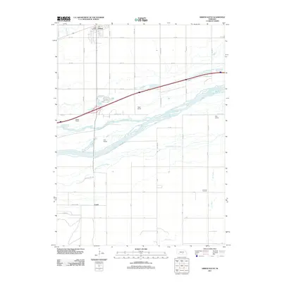
2011 Map of Gibbon South
USGS Topo · Published 2011About this map
The braided channels of the Platte River dominate this 2011 survey, illustrating a complex riparian landscape south of Gibbon. This particular stretch is defined by the North Channel, Middle Channel, and South Channel, which carve out significant landmasses such as Carl Island, Clark Island, and Elm Island. The settlement of Gibbon sits in the northwest, marked by its Gibbon Post Office, while the small community of Lowell is situated further south near the edge of the river bottom. The grid of rural roads, including Coal Chute Rd and Elm Island Rd, reflects the agricultural heritage of the region. To the southeast, the Saint Paul Cemetery remains a quiet landmark on the prairie, providing a fixed point for genealogical research among the shifting channels and irrigation ways like Dry Creek.
Find a feature on this map
40 named features on this map. Tap any name to fly to it.
Don’t see what you’re looking for? This feature index may not catch every label — zoom into the map to look around manually.
Map Details
Editions of this 2011 Gibbon South Map
This is the sole edition of this map. No revisions or reprints were ever made.
Other maps of this area

1894 · Kenesaw
USGS Topo · 1:62,500

1894 · Minden
USGS Topo · 1:62,500

1895 · Wood River
USGS Topo · 1:62,500

1896 · Wood River
USGS Topo · 1:125,000

1955 · Grand Island
USGS Topo · 1:250,000

1957 · Grand Island
USGS Topo · 1:250,000

1958 · Grand Island
USGS Topo · 1:250,000

1962 · Denman
USGS Topo · 1:24,000

1962 · Newark
USGS Topo · 1:24,000
1962 · Gibbon North
USGS Topo · 1:24,000
Featured Places
- Gibbon, NE
- Lowell, NE
- Sun Valley Trailer Court, Gibbon
- L and J Mobile Home Court, Gibbon
- Buffalo County, NE