
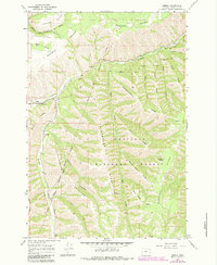
1964 Map of Gibbon
USGS Topo · Published 1966About this map
The Union Pacific railroad corridor defines the western edge of this landscape, following the narrow valley floor where Meacham Creek meets the Umatilla River. This mid-1960s survey captures the intersection of the Umatilla Indian Reservation Boundary and the Umatilla National Forest, a region characterized by a dense network of high ridges and deep canyons. Small settlements like Gibbon and Bonifer are situated near the rail line, which served as a vital transport artery through this complex terrain.
Find a feature on this map
32 named features on this map. Tap any name to fly to it.
Don’t see what you’re looking for? This feature index may not catch every label — zoom into the map to look around manually.
Map Details
Editions of this 1964 Gibbon Map
2 editions found
Other maps of this area

1953 · Pendleton
USGS Topo · 1:250,000

1956 · Pendleton
USGS Topo · 1:250,000

1963 · Bingham Springs
USGS Topo · 1:24,000

1963 · Blalock Mountain
USGS Topo · 1:24,000

1964 · Thorn Hollow
USGS Topo · 1:24,000

1964 · Athena
USGS Topo · 1:24,000

1964 · Weston Mountain
USGS Topo · 1:24,000

1964 · Duncan
USGS Topo · 1:24,000

1964 · Thimbleberry Mtn
USGS Topo · 1:24,000

1964 · Meacham
USGS Topo · 1:24,000