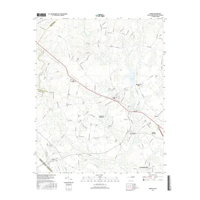
2016 Map of Gibson
USGS Topo · Published 2016About this map
Laurinburg and the surrounding borderlands between North Carolina and South Carolina are defined by a complex network of waterways and early industrial sites. The industrial legacy of the region is evident at Richmond Mill and Ida Mill, where water power from Gum Swamp Cr and its tributaries supported local development. Small settlements like Old Hundred, Livingstons Quarters, and Laurel Hill are scattered throughout the landscape, connected by historic routes such as Old Wire Rd. This 2016 survey documents a high density of family and community burial grounds, including the Old Hundred Cem, Saint Johns Cem, and Peels Chapel Cem, which serve as vital markers for local genealogical research. The CSX railroad corridor remains a primary transportation spine, cutting through the terrain alongside drainage systems like Upper Beaverdam Cr and Beaver Dam Cr.
Find a feature on this map
133 named features on this map. Tap any name to fly to it.
Don’t see what you’re looking for? This feature index may not catch every label — zoom into the map to look around manually.
Map Details
Editions of this 2016 Gibson Map
This is the sole edition of this map. No revisions or reprints were ever made.
Other maps of this area

1942 · Rockingham
USGS Topo · 1:125,000

1949 · Gibson
USGS Topo · 1:24,000

1949 · Ghio
USGS Topo · 1:24,000

1949 · Laurinburg
USGS Topo · 1:24,000

1949 · Silver Hill
USGS Topo · 1:24,000

1949 · Marston
USGS Topo · 1:24,000

1949 · Hamlet
USGS Topo · 1:24,000

1949 · Hamlet
USGS Topo · 1:62,500

1949 · Laurinburg
USGS Topo · 1:62,500

1953 · Florence
USGS Topo · 1:250,000