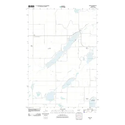
2010 Map of Giese
USGS Topo · Published 2010About this map
The small settlement of Giese serves as the focal point for this rural landscape in Pine County, defined by a series of interconnected glacial lakes and managed water systems. The map illustrates the careful control of the local hydrography, featuring the Big Pine Lake Dam, Thomas Digman Dam, and Bald Eagle Lake Dam. These structures manage the flow through Big Pine Lake and Pine Lake, which are central to the area's geography.
Find a feature on this map
60 named features on this map. Tap any name to fly to it.
Don’t see what you’re looking for? This feature index may not catch every label — zoom into the map to look around manually.
Map Details
Editions of this 2010 Giese Map
This is the sole edition of this map. No revisions or reprints were ever made.
Other maps of this area

1953 · Duluth
USGS Topo · 1:250,000

1958 · Duluth
USGS Topo · 1:250,000

1961 · Sandstone
USGS Topo · 1:62,500

1961 · Moose Lake
USGS Topo · 1:62,500

1968 · Kroschel NW
USGS Topo · 1:24,000

1968 · Pomroy Lake
USGS Topo · 1:24,000

1968 · Giese
USGS Topo · 1:24,000
1968 · Kroschel
USGS Topo · 1:24,000

1969 · Solana
USGS Topo · 1:24,000

1969 · Arthyde
USGS Topo · 1:24,000