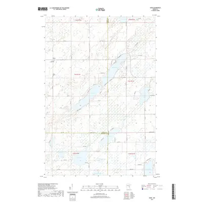
2019 Map of Giese
USGS Topo · Published 2019About this map
Giese sits at the intersection of local history and the marshy landscape of northern Minnesota, marking a pocket of settlement where the borders of Pine, Aitkin, and Kanabec counties converge. The terrain is defined by a glacial chain of water bodies, including the expansive Big Pine Lake, Pine Lake, and Upper Pine Lake, which dominate the central and eastern portions of the map. These lakes are connected by a network of small waterways like Little Pine Cr and the Pine River. Genealogists will find particular value in the presence of Immanuel Lutheran Cem and the Wagner Township Cem near Giese, which anchor the local community history. The road network, including names like Appaloosa Pass and Sunset Lodge Rd, suggests a landscape transitioning from traditional rural townships to one with seasonal and recreational lakeside activity.
Find a feature on this map
79 named features on this map. Tap any name to fly to it.
Don’t see what you’re looking for? This feature index may not catch every label — zoom into the map to look around manually.
Map Details
Editions of this 2019 Giese Map
This is the sole edition of this map. No revisions or reprints were ever made.
Other maps of this area

1953 · Duluth
USGS Topo · 1:250,000

1958 · Duluth
USGS Topo · 1:250,000

1961 · Sandstone
USGS Topo · 1:62,500

1961 · Moose Lake
USGS Topo · 1:62,500

1968 · Kroschel NW
USGS Topo · 1:24,000

1968 · Pomroy Lake
USGS Topo · 1:24,000

1968 · Giese
USGS Topo · 1:24,000
1968 · Kroschel
USGS Topo · 1:24,000

1969 · Solana
USGS Topo · 1:24,000

1969 · Arthyde
USGS Topo · 1:24,000