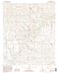
1985 Map of Gila Box
USGS Topo · Published 1986About this map
The Gila River carves through a labyrinth of canyonlands at the border of Graham and Greenlee counties, revealing a landscape dominated by dramatic topographic relief and vital water catchments. The sharp bend at Camel Back Gila and the confluence with Eagle Creek highlight the importance of river corridors in this arid environment. To the north, the massive uplift of Turtle Mountain dictates the drainage patterns for numerous seasonal courses like Phillip Canyon and Bill Roy Canyon.
Find a feature on this map
32 named features on this map. Tap any name to fly to it.
Don’t see what you’re looking for? This feature index may not catch every label — zoom into the map to look around manually.
Map Details
Editions of this 1985 Gila Box Map
This is the sole edition of this map. No revisions or reprints were ever made.
Other maps of this area

1902 · Clifton
USGS Topo · 1:62,500

1913 · Morenci
USGS Topo · 1:125,000

1915 · Morenci
USGS Topo · 1:125,000

1954 · Silver City
USGS Topo · 1:250,000

1954 · Clifton
USGS Topo · 1:250,000

1957 · Clifton
USGS Topo · 1:250,000

1958 · Silver City
USGS Topo · 1:250,000

1958 · Clifton
USGS Topo · 1:250,000

1960 · Guthrie
USGS Topo · 1:62,500

1960 · Safford
USGS Topo · 1:62,500