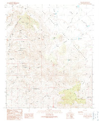
1989 Map of Gila Peak
USGS Topo · Published 1990About this map
Gila Peak rises as the central landmark of this high-desert landscape in Graham County, where the southern portion of the San Carlos Indian Reservation meets a network of remote canyons and washes. The terrain is defined by complex drainage systems like Fishhook Canyon, Middle Canyon, and Sevenmile Canyon, which feed into the broader Ash Flat. Evidence of early cattle ranching and water management is pervasive throughout the survey, with numerous named tanks and wells such as Morman Spring Tank, Burdette Tank, and the Dutch Pasture Well scattered across the flats and draws.
Find a feature on this map
60 named features on this map. Tap any name to fly to it.
Don’t see what you’re looking for? This feature index may not catch every label — zoom into the map to look around manually.
Map Details
Editions of this 1989 Gila Peak Map
This is the sole edition of this map. No revisions or reprints were ever made.
Other maps of this area

1954 · Clifton
USGS Topo · 1:250,000

1954 · Mesa
USGS Topo · 1:250,000

1957 · Mesa
USGS Topo · 1:250,000

1957 · Clifton
USGS Topo · 1:250,000

1958 · Clifton
USGS Topo · 1:250,000

1958 · Mesa
USGS Topo · 1:250,000

1960 · Mesa
USGS Topo · 1:250,000

1960 · Bylas
USGS Topo · 1:62,500

1960 · Fort Thomas
USGS Topo · 1:62,500

1962 · Clifton
USGS Topo · 1:250,000